Agroecology schools help communities restore degraded land in Guatemala

Agroecology schools help communities restore degraded land in Guatemala

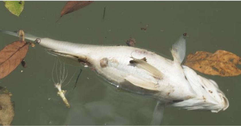
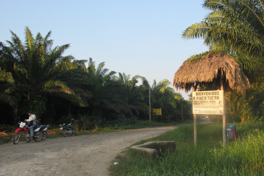
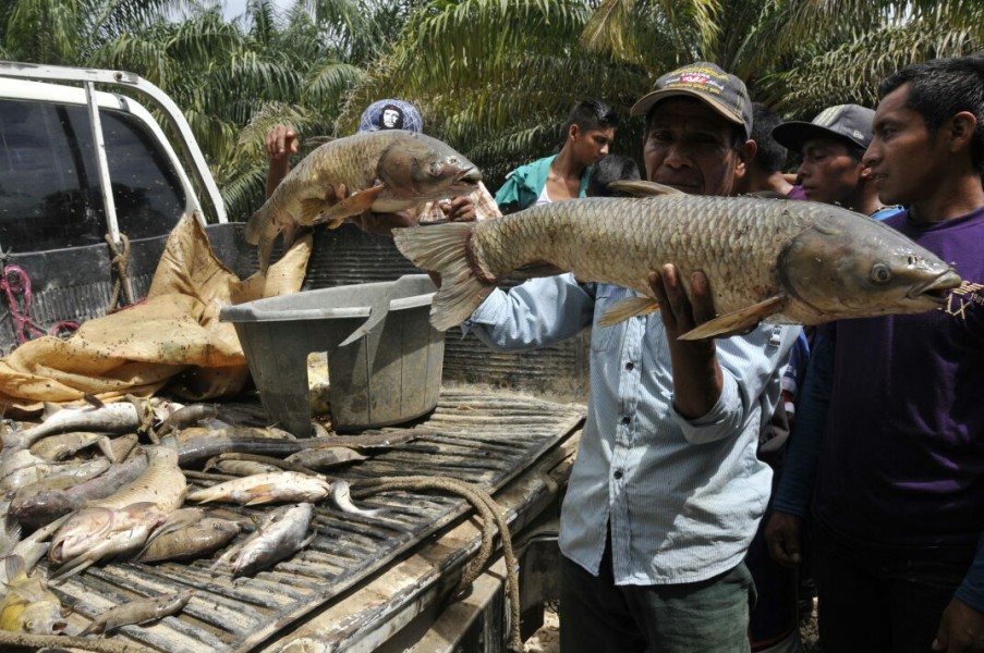
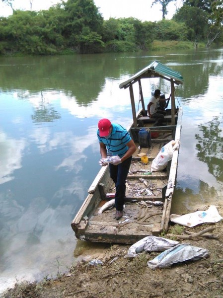
  • The transformation of ancestral lands into intensive monoculture plantations has led to the destruction of Guatemala’s native forests and traditional practices, as well as loss of livelihoods and damage to local health and the environment.
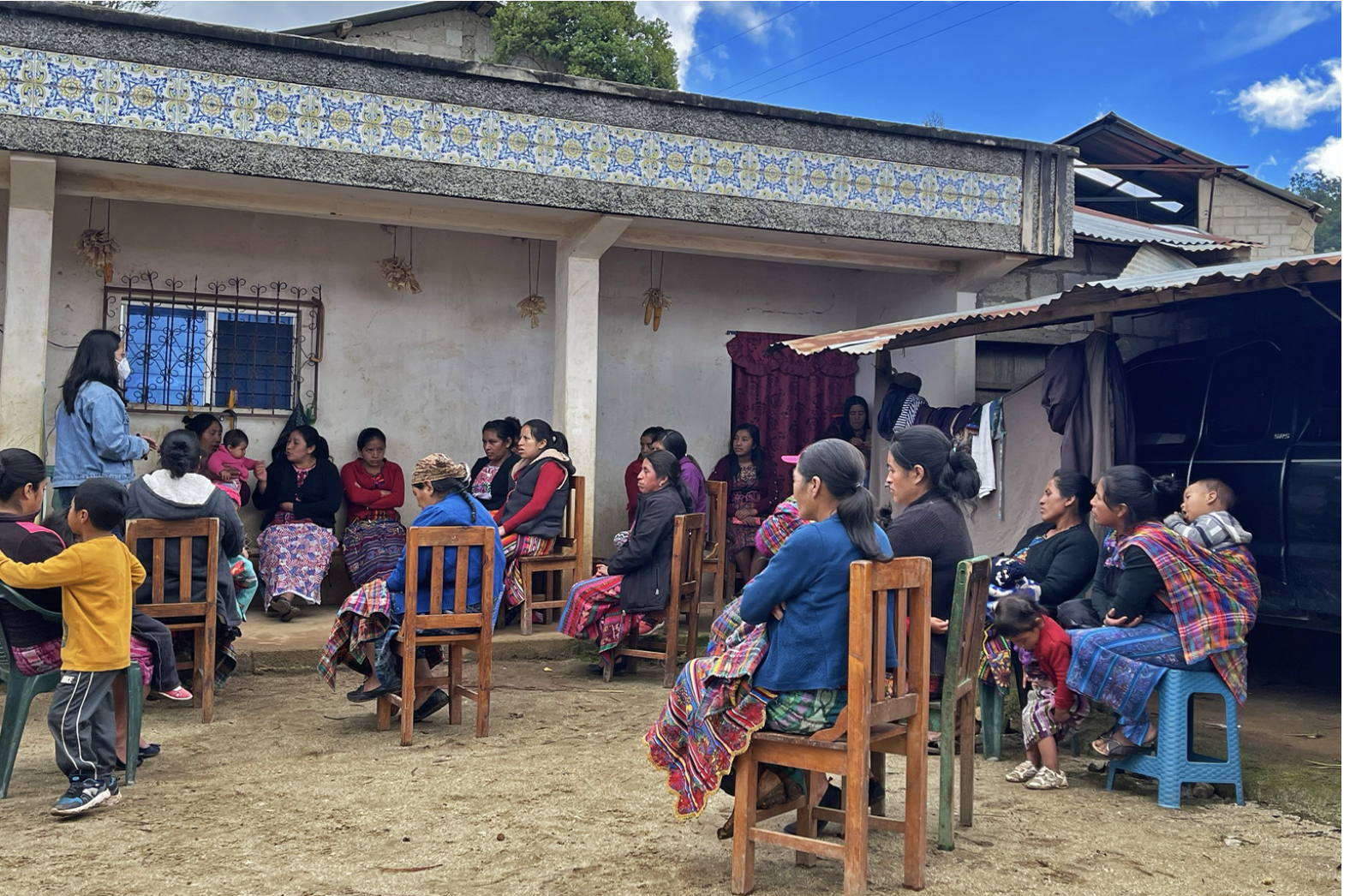
  • A network of more than 40 Indigenous and local communities and farmer associations are developing agroecology schools across the country to promote the recovery of ancestral practices, educate communities on agroecology and teach them how to build their own local economies.
  • Based on the traditional “campesino a campesino” (from farmer to farmer) method, the organizations says it has improved the livelihoods of 33,000 families who use only organic farming techniques and collectively protect 74,000 hectares (182,858 acres) of forest across Guatemala.

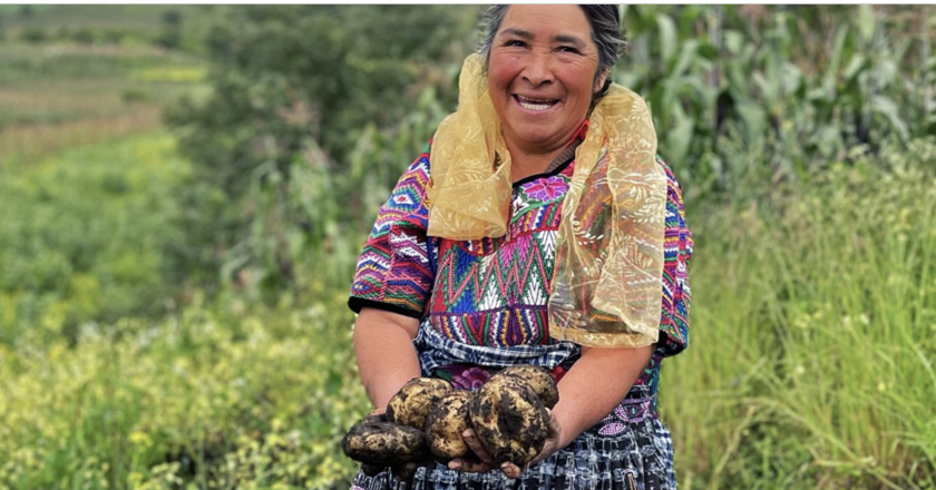
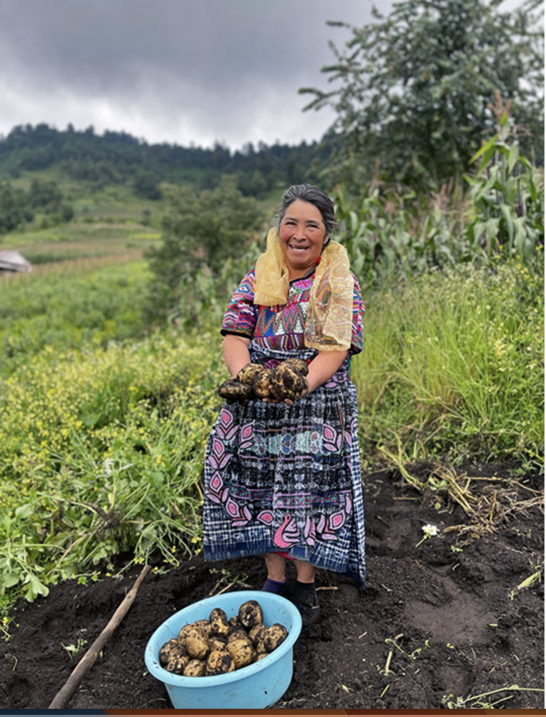
Every Friday at 7:30 a.m., María Isabel Aguilar sells her organic produce in an artisanal market in Totonicapán, a city located in the western highlands of Guatemala. Presented on a handwoven multicolor blanket, her broccoli, cabbage, potatoes and fruits are neatly organized into handmade baskets.

Aguilar is in a cohort of campesinos, or small-scale farmers, who took part in farmer-led agroecology schools in her community. As a way out of the cycle of hunger and poverty, she learned ecological principles of sowing, soil conservation, seed storage, propagation and other agroecological practices that have provided her with greater autonomy, self-sufficiency and improved health.

“We learned how to develop insecticides to fend off pests,” she said. The process, she explained, involves a purely organic cocktail of garlic, chile, horsetail and other weeds and leaves, depending on what type of insecticide is needed. “You want to put this all together and let it settle for several days before applying it, and then the pests won’t come.”

“We also learned how to prepare fertilizer that helps improve the health of our plants,” she added. “Using leaves from trees or medicinal plants we have in our gardens, we apply this to our crops and trees so they give us good fruit.”

The expansion of large-scale agriculture has transformed Guatemala’s ancestral lands into intensive monoculture plantations, leading to the destruction of forests and traditional practices. The use of harmful chemical fertilizers, including glyphosate, which is prohibited in many countries, has destroyed some livelihoods and resulted in serious health and environmental damage.

To combat these trends, organizations across the country have been building a practice called campesino a campesino (from farmer to farmer) to revive the ancient traditions of peasant families in Guatemala. Through the implementation of agroecology schools in communities, they have helped Indigenous and local communities tackle modern-day rural development issues by exchanging wisdom, experiences and resources with other farmers participating in the program.

‘Learning by doing’ is one of the guiding principles of Guatemala’s agroecology schools. Although some schools have theoretical elements, most lessons take place on farms, rather than classrooms. Image courtesy of Utz Che’.

Keeping ancestral traditions alive

The agroecology schools are organized by a network of more than 40 Indigenous and local communities and farmer associations operating under the Utz Che’ Community Forestry Association. Since 2006, they have spread across several departments, including Totonicapán, Quiché, Quetzaltenango, Sololá and Huehuetenango, representing about 200,000 people — 90% of them Indigenous.

“An important part of this process is the economic autonomy and productive capacity installed in the communities,” said Ilse De León Gramajo, project coordinator at Utz Che’. “How we generate this capacity and knowledge is through the schools and the exchange of experiences that are facilitated by the network.”

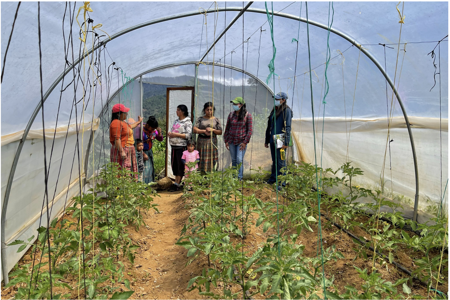
Utz Che’, which means “good tree” in the K’iche’ Mayan language, identifies communities in need of support and sends a representative to set up the schools. Around 30-35 people participate in each school, including women and men of all ages. The aim is to facilitate co-learning rather than invite an “expert” to lead the classes.

The purpose of these schools is to help farmers identify problems and opportunities, propose possible solutions and receive technical support that can later be shared with other farmers.

The participants decide what they want to learn. Together, they exchange knowledge and experiment with different solutions to thorny problems. If no one in the class knows how to deal with a certain issue, Utz Che’ will invite someone from another community to come in and teach.

“We identify a producer who has specific experience in a subject — for example, potato production, pig production or seed reproduction — and through this process, we transfer knowledge between farmers,” Gramajo said.

In each school, a cohort of farmers will generate a list of problems they face or skills they’d like to learn, such as propagation and seed storage. Classes, talks, workshops and field visits are then organized around these topics. Image courtesy of Utz Che’.

Attendance is free. However, as part of the process, former students are responsible for supporting the next cohort of farmers, by offering technical support and guidance. The process replicates the natural passing down of knowledge through generations of farmers, hence its name campesino a campesino.

Nils McCune, an agroecological researcher at the University of Vermon, said this type of approach “starts with the recognition that farmers are the best teachers of farmers.”

Like agroecology schools organized by the Landless Workers Movement in Brazil (or MST, its acronym in Portuguese), classes are both theoretical and practical. However, the Guatemalan schools take place on participants’ farms rather than on a formal campus.

Gramajo pointed to Florinda Dominga Par, from a community called Chuicaxtun, who has been in the program since 2014.

“In the schools, she learned how to produce bokashi fertilizer,” a composting method that involves fermenting organic manure, “which has become her greatest ally for potato production,” said Gramajo. “Today, she is one of the best producers of organic potatoes.”

Florinda Dominga Par is an active participant in the agroecological and artisanal market held every Friday in Totonicapán, a space generated specifically for agroecological producers. She is considered one of the best producers of organic potatoes in the country. Image courtesy of Utz Che’.

Farmers can also learn about the selection and protection of native seeds, the planting and agricultural management of their crops, soil conservation and rainwater harvesting for irrigation or animals.

Caterina Tzic Canastuj, another producer who has participated in the schools, told Mongabay she learned how to create an organic fertilizer called chitosan, which protects her tomatoes against harmful microorganisms, resulting in much larger, high-quality yields.

Part of what Utz Che’ does is document ancestral practices to disseminate among schools. Over time, the group has compiled a list of basics that it considers to be fundamental to all the farming communities, most of which respond to the needs and requests that have surfaced in the schools.

Agroecology schools transform lives

Claudia Irene Calderón, based at the University of Wisconsin-Madison, is an expert in agroecology and sustainable food systems in Guatemala. She said she believes the co-creation of knowledge is “key to balance the decision-making power that corporations have, which focus on profit maximization and not on climate change mitigation and adaptation.”

“The recovery and, I would add, revalorization of ancestral practices is essential to diversify fields and diets and to enhance planetary health,” she said. “Recognizing the value of ancestral practices that are rooted in communality and that foster solidarity and mutual aid is instrumental to strengthen the social fabric of Indigenous and small-scale farmers in Guatemala.”

Through the implementation of agroecology schools across the country, Utz Che’ says it has improved the livelihoods of 33,000 families. In total, these farmers also report that they collectively protect 74,000 hectares (182,858 acres) of forest across Guatemala by fighting fires, monitoring illegal logging and practicing reforestation.

In 2022, Utz Che’ surveyed 32 women who had taken part in the agroecology school. All the women had become fully responsible for the production, distribution and commercialization of their products, which was taught to them in agroecology schools. Today, they sell their produce at the artisanal market in Totonicapán.

The findings, which highlight the many ways the schools helped them improve their knowledge, also demonstrate the power and potential of these schools to increase opportunities and strengthen the independence of women producers across the country.

View related coverage of agroecology schools in Brazil and India

For McCune, agroecology, shared through a social process like campesino a campesino, results in healthier food using less land, all while reducing the harmful impacts of intensive agriculture on the health, water and food sources of communities.

“It is probably the most clearly successful of any methods for mobilizing agroecological knowledge,” he said. “However, as a social process, campesino a campesino has to swim in the turbulent waters of changing sociopolitical contexts.”

As Gramajo pointed out, one of the greatest challenges they face is the lack of support from governments that lean toward agricultural models that aim to maximize profit at the expense of rural communities.

“There are several agreements and international treaties to support farmers in Guatemala, but these are not respected,” she said. “This is a big challenge.”

Although some of the advances of the agricultural industry’s expansion in Guatemala have been useful, such as the development of more efficient irrigation systems, post-harvest technologies and a greater understanding of plant-pathogen interactions, “the optimization of the systems to focus solely on the maximization of production is risky,” said Calderón, adding, “it has been shown to have very negative environmental and social impacts.”

Gramajo said the schools focus on “activities that strengthen the economy of the families and reduce the threats that are generated from the exploitation of natural resources, such as the deforestation that’s carried out in some areas to clear space for monocultures and the advancement of the agricultural industry.”

The schools are centered around the idea that people are responsible for protecting their natural resources and, through the revitalization of ancestral practices, can help safeguard the environment and strengthen livelihoods.


Learning about the cultural significance of textiles with the ‘Woven Identities’ exhibit

Learning about the cultural significance of textiles with the ‘Woven Identities’ exhibit

‘Woven Identities’ is an exhibit that explores the intriguing patterns and unique motifs of Ghanaian and Guatemalan textiles and their cultural significance. Visit Woven Identities in person until March 1 at the Human Ecology Gallery on North Campus.


Throughout history, clothing, including the patterns, fabrics and techniques used, has served as a distinct form of cultural expression across the world. In ‘Woven Identities’, curators Siming Guo, Elsie Osei, Chiara Power and Anne Bissonnette explored two countries whose people have long expressed themselves through clothing and textiles: Ghana and Guatemala.

Textiles in Ghana and Guatemala

In this exhibit, walk through, explore and learn about the woven designs and processes developed by Ghanaians and the Indigenous Maya people of Guatemala. The exhibit demonstrates that despite being on opposite sides of the world, both countries’ strong weaving, printing and embroidering traditions have generated colourful, intricate textiles that are recognized worldwide.

The two styles of dress, as shared through the exhibit website, share a collective purpose: “Ghanaian textiles are remarkable with their unique motifs and patterns, which reflect the country’s Indigenous cultural heritage. With Maya textiles, while some of their visual elements could once be linked to a wearer’s location, age or gender, the broader use of traje — Maya traditional dress — now plays a part in Indigenous identity politics.”

“Interestingly, despite the apparent differences, cultures worldwide share striking similarities upon closer examination,” shared exhibit curator, Elsie Osei, MFA. “The world, in essence, operates as a global market, and the perceived distance between various cultures diminishes when scrutinized. It becomes evident that many cultures grapple with common influences, such as the effects of globalization, colonization and other shared experiences.”

Globalization and textiles

One focus for this exhibit is the impact of globalization: the curators highlight how Western gender standards have had a greater impact on the negative perception of men in traje as they do not conform to a somber vision of masculinity. Moreover, you can see the Kente cloth being worn across the world to signal African heritage.

Beyond cultural symbolism, new technologies have also been introduced — leading to the use of manufactured threads and synthetic dyes by Maya weavers as substitutes to natural yarns and dyes.

What’s next for the curation team and exhibit? 

The exhibit, which opened April 12, 2023, comes to a close on March 1, 2024.

“Curating this exhibition proved to be an exhilarating experience for me,” Elsie commented. “I gained valuable insights throughout the process and cherished the camaraderie within the team. Being a proud Ghanaian, my passion for highlighting our rich culture and traditions found a meaningful outlet in this endeavour, marking a promising beginning.”


“Exploring the Anne Lambert Clothing and Textile Collection, analyzing and discussing the objects, and ‘dressing’ the mannequins were undeniably the highlights of my curation journey. The vast array of historic clothing and textiles within the collection was a captivating adventure, reminiscent of a child in a candy store,” Elsie said.

The graduate student co-curators of the exhibition: Chiara Power, Elsie Osei and Siming Guo

In May 2024, Chiara and Anne will travel to Washington, D.C., for a juried presentation on the exhibition at the Annual Symposium of the Costume Society of America (CSA).

Research for the design of the exhibition has also led to one juried paper written by Anne for Dress, the Costume Society of America scholarly journal. The article, ‘Increasing Mannequin Diversity in Museum Exhibitions to Address Social Justice…’ discusses how — for far too long — museums have used thin, white mannequins as the standard for body surrogates in dress and textiles exhibitions.

Along with a brief summary of the practice, the paper offers alternatives called ‘The Forest People’ that aims to address issues of equity, diversity and inclusion in curatorial and display practices by making or covering mannequins in an array of wood colors and textures to simulate the diversity of skin tones.


Guatemalan students visit OU to learn more about freshwater ecology, sustainability

Guatemalan students visit OU to learn more about freshwater ecology, sustainability

A group of students from Guatemala recently visited Oakland University to learn more about freshwater ecology and sustainability in Michigan as part of a collaborative program with OU’s Office of International Education and the Department of Biological Sciences.

“OU students actually visited Guatemala in May as part of a Tropical Field Ecology course, during which they met the students who came to OU this month,” said Scott Tiegs, a professor of biological sciences at OU.

The exchange was sponsored by a grant from the U.S. State Department’s 100,000 Strong in the Americas program, which is meant to increase student mobility in the Western Hemisphere. The $25,000 grant was awarded to OU in 2019 based on a proposal submitted by Tiegs and Alex Zimmerman, director of International Education.

“We had to delay the project until now due to the pandemic, so it was very gratifying to finally be able to bring the students here,” Zimmerman said.

As part of their research, the Guatemalan students visited Paint Creek in Orion Township to collect samples of macroinvertebrates — animals that lack a backbone and are large enough to be seen with the naked eye, including aquatic insects, crayfish, snails, clams, and worms — in order to assess the creek’s water quality.

“By looking at the different species that are present in Paint Creek, we can infer a lot about how healthy an ecosystem it is,” Tiegs said. “Some invertebrates are very sensitive to pollution, so when it is present they will disappear from that stream. Other invertebrates are very tolerant of pollution, so they thrive under those conditions. By looking at the abundance of tolerant versus intolerant invertebrates, we’re able to infer a lot about the health of that stream.”

For many of the Guatemalan students, using macroinvertebrates to assess the quality of the water in the creek was a technique they weren’t familiar with.

“It was a great opportunity for them to learn a new technique,” Tiegs said.

It was also a unique experience for the students because many of the insects and animals they found in Paint Creek aren’t found in Guatemala.

“It was very interesting to see the different species there,” said Guatemalan student Jabel Gómez. “I’m very excited to compare these macroinvertebrates and apply what I learn to my future studies in Guatemala.”

Antonella Fuentes, also from Guatemala, agreed.

“It was very interesting,” she said. “Being there really expanded my knowledge about macroinvertebrates and their role in a healthy ecosystem.”

Elizabeth “Lizz” Parkinson, a doctoral student in Oakland University’s Aquatic Ecology Lab in the Department of Biological Sciences and head of the Freshwater Forum at Cranbrook Institute of Sciences, accompanied Tiegs and the students as the collected the samples from the creek.

“One of the things I hope the students get out of their experience is to see the different types of invertebrates that we have here in Michigan,” she said. “While a lot of these orders of invertebrates are unique to Michigan, some are also found in Guatemala, so there are similarities and differences between what they see here and what we see there, which is great because it connects the freshwater in the two places. Also, they’re able to get a taste of what we do with our students here and how we monitor water quality.”

In addition to collecting samples at Paint Creek, the students also went for a hike at Bald Mountain in Orion Township, and took a trip to Sutton’s Bay near Traverse City, where they went kayaking on Crystal River and climbed the Sleeping Bear Dunes. After returning from Sutton’s Bay, the students had an opportunity to tour a water treatment facility in Pontiac, visit the Cranbrook Institute of Science, and walk around Belle Isle and the Detroit Riverfront.

Deforestation, certification, and transnational palm oil supply chains: Linking Guatemala to global consumer markets

Deforestation, certification, and transnational palm oil supply chains: Linking Guatemala to global consumer markets

Abstract

Although causal links between tropical deforestation and palm oil are well established, linking this land use change to where the palm oil is actually consumed remains a distinct challenge and research gap. Supply chains are notoriously difficult to track back to their origin (i.e., the ‘first-mile’). This poses a conundrum for corporations and governments alike as they commit to deforestation-free sourcing and turn to instruments like certification to increase supply chain transparency and sustainability. The Roundtable on Sustainable Palm Oil (RSPO) offers the most influential certification system in the sector, but whether it actually reduces deforestation is still unclear. This study used remote sensing and spatial analysis to assess the deforestation (2009–2019) caused by oil palm plantation expansion in Guatemala, a major palm oil source for international consumer markets. Our results reveal that plantations are responsible for 28% of deforestation in the region and that more than 60% of these plantations encroach on Key Biodiversity Areas. RSPO-certified plantations, comprising 63% of the total cultivated area assessed, did not produce a statistically significant reduction in deforestation. Using trade statistics, the study linked this deforestation to the palm oil supply chains of three transnational conglomerates – Pepsico, Mondelēz International, and Grupo Bimbo – all of whom rely on RSPO-certified supplies. Addressing this deforestation and supply chain sustainability challenge hinges on three measures: 1) reform of RSPO policies and practices; 2) robust corporate tracking of supply chains; and 3) strengthening forest governance in Guatemala. This study offers a replicable methodology for a wide-range of investigations that seek to understand the transnational linkages between environmental change (e.g. deforestation) and consumption.

Introduction

Tropical deforestation – which is primarily driven by commodity production – has major, potentially irreversible, global implications for biodiversity (Benton et al., 2021), ecosystem functioning (IPBES, 2019), soil health (Foley et al., 2005), hydrological cycles (Bala et al., 2007), carbon emissions (Smith et al., 2014), and livelihoods (Newton and Benzeev, 2018). Beef, palm oil, soy, and wood products alone account for 40% of tropical deforestation globally (Henders et al., 2015).

Palm oil is particularly pernicious given its near ubiquity. Cheap, versatile, and easy to grow, it is the world’s most consumed vegetable oil and is found in roughly half of all packaged supermarket products – from bread and butter, to shampoo and toothpaste (WWF, 2022a). Since 2000, palm oil production has more than tripled (Ceres, 2022) and an additional 36 million hectares (ha) of land will be required by 2050 to meet projected demand (Meijaard et al., 2020).

Scholarship on the connection between palm oil and deforestation has primarily focused on Southeast Asia, especially Indonesia and Malaysia, where most production occurs (Pendrill et al., 2019). But the region’s producers face shrinking land availability and increasing scrutiny, driving expansion in new production geographies. With the largest global forest reserves suitable for oil palm production, Latin America has emerged as the next frontier and is already the second largest producing region (Castellanos-Navarrete et al., 2021; Furumo and Aide, 2017). In the span of just one decade (2010–2020), palm oil production in Latin America has more than doubled (FAOSTAT, 2020).

Palm oil expansion has been especially rapid in Guatemala, which boasts the highest productivity per ha globally (Tropical Forest Alliance, 2019). By 2030, Guatemala is projected to become the world’s third largest palm oil producer, after Indonesia and Malaysia (Tropical Forest Alliance, 2019). With conversion of forestland to oil palm plantations well-underway, conservationists are especially concerned about incursion into the Maya Biosphere Reserve, the largest contiguous rainforest in Guatemala (Barnhart, 2020; Furumo and Aide, 2017; Hodgon et al., 2015; Kuepper et al., 2021).

Unrelenting deforestation in the tropics from palm oil and other commodities has prompted the European Union to craft regulations requiring supply chains to be deforestation-free (European Commission, 2022). National governments are following suit, including in the U.K and the U.S. (FOREST Act of, 2021, Department for Environment and Rural Affairs DEFRA). Climate change mitigation policies, in both public and private sectors, are also starting to require accounting for Scope 3 greenhouse gas emissions, including those associated with land use (Gensler, 2022).

Voluntary certification schemes have emerged as a primary mechanism for improving supply chain transparency and commodity production practices, including meeting deforestation-free targets (Drost et al., 2022; Garrett et al., 2019; Lambin et al., 2018; Milder et al., 2015; RSPO, 2022). The Roundtable on Sustainable Palm Oil (RSPO) is among the most prominent of these certification initiatives and it is the only global sustainability standard covering edible oils (Bennett, 2017; Cattau et al., 2016; Pacheco et al., 2020; Pattberg, 2007). Certified members conform to a set of “Principles and Criteria” that ostensibly address environmental and social impacts associated with production (RSPO, 2020). This includes the protection of High Conservation Value and High Carbon Stock forests (Gatti et al., 2019; RSPO, 2020). Yet, in many ways the RSPO’s effectiveness for forest protection is still debated (Carlson et al., 2018; Cattau et al., 2016; Dauvergne, 2018; Gatti et al., 2019; Gatti and Velichevskaya, 2020; Heilmayr et al., 2020a; Lee et al., 2020; Meijaard et al., 2017; Morgans et al., 2018; Noojipady et al., 2017).

These policy efforts all seek to harness the power of consumer markets to shape production practices in distant geographies. Land change science scholars describe these linkages between geographies of production and consumption as teleconnections or telecoupled systems (Seto et al., 2012). But unweaving the complex, often opaque supply chain linkages between sites of production and consumption is a distinct challenge. Although scholars have mapped broad sectoral flows connecting land cover change in one region to consumption in another (Friis and Nielsen, 2017), we generally lack sufficient tools to track corporate-specific supply chains, whether for giant multinational food conglomerates or smaller commodity-specific companies (Escobar et al., 2020; Goldstein and Newell, 2019, 2020; Hansen et al., 2022). Yet, given the enormous power these actors wield in the global economy, changing their behavior is necessary for the sustainable transition of production-consumption systems (Goldstein and Newell, 2019). Targeting the actions of just a few corporate actors can have profound impact.

In light of this, this study tracks the palm oil sourced from forestland and other ecologically critical areas of Guatemala by three transnational conglomerates – PepsiCo, Mondelēz International (hereafter, “Mondelēz”), and Grupo Bimbo – that sell food products made from this palm oil in the U.S. PepsiCo and Mondelēz International are the world’s largest snack food companies while Grupo Bimbo is the third most powerful food conglomerate in the U.S. (Euromonitor International, 2021, Euromonitor International, 2022). All three are members of the RSPO and rely on RSPO-certified palm oil for their products (Grupo Bimbo, 2022a, Mondelēz International, 2023, PepsiCo, 2022a). Through this case study we seek to answer the following questions.

  • 1.

    Where is palm oil grown in Guatemala and to what degree is it contributing to deforestation and ecological encroachment?

  • 2.

    From where in Guatemala are these conglomerates importing palm oil and what are their supply chain configurations, from forest to consumer market?

  • 3.

    Is RSPO-certification effective in reducing risks related to deforestation and ecological encroachment in these supply chains?

To answer these questions, we combined remote sensing, machine learning, and spatial analysis in concert with a methodological approach known as Tracking Corporations Across Space and Time (TRACAST) (Goldstein and Newell, 2020). Our results indicate that over a decade (2009–2019), a significant proportion of palm oil expansion in Guatemala led to deforestation and ecological encroachment. Supply chain reconstruction reveals explicit linkages between PepsiCo, Mondelēz, and Grupo Bimbo, these plantations, and their impacts. We do not find evidence that RSPO-certification effectively protects against deforestation or ecological encroachment. This suggests that despite company policies for complete, or near complete, RSPO coverage of their palm oil supplies, certification, at least in the context of Guatemala, is not an effective mechanism for guaranteeing corporate zero-deforestation commitments or robustly protecting against other environmental sourcing risks.

We conclude with concrete suggestions for improving the RSPO, as well as recommendations for advancing legislation and supply chain traceability and transparency, especially by tackling the “first-mile” problem. This problem is not limited to palm oil. Opaque supply chain origins impede our ability to link transnational supply chains to environmental and social impacts across all sectors (VanderWilde et al., 2023). Although this study prioritizes environmental impacts, how palm expansion affects livelihoods and land rights is equally important, including those of Indigenous Peoples and communities.

The utility of this study extends beyond Guatemala, palm oil, or even commodity production. It presents a broadly replicable and systematic method to uncover connections between complex transnational supply chains and distant land use change. Excavating and mapping these teleconnections provides a springboard for future work on production-consumption linkages, environmental degradation, carbon emissions, justice and equity, and corporate greenwash and governance.

Section snippets

Materials and methods

This study used remote sensing and machine learning to quantify deforestation attributable to oil palm expansion in Guatemala over a decade (2009–2019) and to assess whether RSPO-certification reduced this deforestation. To identify palm oil supply chain production-consumption linkages for three food conglomerates (PepsiCo, Mondelez, and Group Bimbo), we used the TRACAST methodological framework (Goldstein and Newell, 2020).

Results

Our results indicate the supply chains of transnational conglomerates caused deforestation and ecological encroachment in Guatemala to support U.S. palm oil consumption. We estimated that oil palm plantations expanded 87,325 ha between 2009 and 2019 with 28% (24,609 ha) replacing forestland. A majority of oil palm plantations encroach on ecologically significant areas, replacing valuable habitat. We did not find evidence to suggest that RSPO-certification effectively protects against

Discussion

This work addresses gaps in the literature concerning corporate-specific supply chains, first-mile traceability, and the forest protection benefits offered by RSPO certification. Our findings reveal a number of interesting discussion points. First, the length and complexity of palm oil supply chains, like many other globalized product systems, make it difficult to establish causal links between land use change and consumption-based drivers. The first-mile problem in particular hinders the

Conclusion

Palm oil has attracted significant attention for its ties to widespread forest and biodiversity loss across Southeast Asia. However, the literature has paid minimal attention to newer spaces of production and issues of corporate supply chain traceability. Understanding corporate-specific supply chains, from their origins, is critical for creating targeted interventions to address teleconnections to environmental and social impacts – and for empowering companies themselves with the knowledge to

Credit author statement

Conceptualization: Calli P. VanderWilde; Joshua P. Newell; Dimitrios Gounaridis; Benjamin P. Goldstein. Methodology: Calli P. VanderWilde; Joshua P. Newell; Dimitrios Gounaridis; Benjamin P. Goldstein. Software: Calli P. VanderWilde; Dimitrios Gounaridis. Validation: Calli P. VanderWilde; Dimitrios Gounaridis. Formal analysis: Calli P. VanderWilde; Dimitrios Gounaridis. Investigation: Calli P. VanderWilde. Resources: Calli P. VanderWilde. Data Curation: Calli P. VanderWilde; Dimitrios

Declaration of competing interest

The authors declare that they have no known competing financial interests or personal relationships that could have appeared to influence the work reported in this paper.

Keeping Guatemala’s Lake Atitlán Crystal Clear

Keeping Guatemala’s Lake Atitlán Crystal Clear

Nestled in between soaring green mountains, Guatemala’s Lake Atitlán is renowned as one of the most beautiful lakes in the world. It is the home of several Mayan communities and is one of Guatemala’s most important tourist destinations. It has also been under threat by massive blooms of algae clotting its pristine waters. In 2009 and 2015, massive “blooms” of algae threatened to cause severe ecological damage.

That is why lake managers now use a web-based tool called the Lake Atitlán Forecasting System. This data dashboard helps them track the health of the lake with NASA Earth science data.

“Every week, I go to the [Forecasting System page] to check on the probability of algal blooms, not just cyanobacteria but of other algae,” said Fátima Reyes. She is the head of the Department of Research and Environmental Quality for the lake’s environmental authority, the Autoridad para el Manejo Sustentable de le Cuenca del Lago de Atitlán y su Entorno (AMSCLAE).

“When the probability [of algae blooms] is high, we share with the team that we need to be attentive and be monitoring the lake. It has been a useful tool for AMSCLAE,” Reyes said.

The Lake Atitlán Forecasting System’s lead scientist is Africa Flores-Anderson, SERVIR’s lead scientist on projects covering land use and land cover.

“Algae blooms in Lake Atitlán alter the ecosystem integrity by affecting the water quality and preventing oxygen and light from reaching fauna and flora living under the water surface,” said Flores. SERVIR is a joint initiative of NASA and the U.S. Agency for International Development (USAID). Its mission is to support locally led environmental efforts in Asia, Africa, and Latin America with the help of NASA’s Earth science and data.

“These blooms have affected water consumption, fishing, and tourism in the area,” she said. “Though the cyanobacteria found in Lake Atitlán is not toxic, its unchecked growth may create an environment for other species of bacteria to take hold–ones that do produce toxins and could contaminate the water.”

After a 2019 algae bloom, Flores received a grant from National Geographic and Microsoft to collaborate with Lake Atitlán’s environmental authority to design the lake forecasting system. Working with her team of scientists based at the University of Alabama in Huntsville, the website gives authorities an early warning if conditions are right for another bloom.

Included in the forecasting system is information from NASA’s Global Precipitation Measurement mission (GPM). It also includes information from a weather forecasting model from the National Oceanic and Atmospheric Administration (NOAA). AMSCLAE scientists validate this space-based data with water samples. This helps them understand how different conditions changed the concentration of cyanobacteria in the water. Warmer, sunnier weather could improve conditions for algae, as well as days when the water is more stagnant.

To fully understand when and where algae blooms might strike, the team also needed to keep an eye on agricultural run-off. To do this, the team also uses a freshwater stream forecasting tool. Developed by the Group on Earth Organizations (GEO)’s Global Water Sustainability (GEOGloWS) group, GEOGloWS’ Streamflow uses cloud computing to process weather information from many satellites. The computer models it creates helps AMSCLAE track how precipitation increases the flow of streams that feed into Atitlán, thus getting an idea of how much fertilizer is being washed in with it.

“Periods of high flows increase hazards for water quality because pesticides and fertilizers applied on the ground and have yet to be uptaken by the crops can be washed into the river during and after storms,” said Dr. Angélica Gutiérrez, a lead scientist with NOAA and a co-chair of GEOGloWS.

The SERVIR team hopes to replicate the success of the Lake Atitlán project to protect other area lakes. While Guatemala was one of the first countries where SERVIR operated, the Central America SERVIR hub closed in 2011. And so, the team also hopes the success of the Lake Atitlán project bolsters SERVIR’s plans to open a new hub in the region within the next year.

Hydrocracy at the Center of Guatemala City’s Elections

Hydrocracy at the Center of Guatemala City’s Elections

Amid cheers, Ninotchka Matute Rodríguez walked onstage in a packed theater at a recent mayoral debate in Guatemala City’s political and cultural city center. On May 25, exactly one month before Guatemala’s general elections, Matute’s presence at the debate dubbed Jóvenes Deciden (Youth Decide) solidified the possibility of her election as Guatemala City’s next and first female mayor. Her flare jeans and black blazer conveyed a casual yet professional demeanor.

With members of her party, Matute walked seven blocks to the event down the Sexta Avenida, the main pedestrian street that connects locals to and from public transportation, the national plaza, and several public parks and cultural centers in the capital’s historic neighborhood. Student and youth organizations, striking workers, and Indigenous and campesino coalitions strategically occupy the avenue for public and political engagement and protest. Matute’s own presence on the avenida is no different.

An architect and urban planner, Matute emerged in the mayoral race shortly after the criminalization of lawyer and municipal candidate Juan Francisco Solórzano Foppa disqualified him from the race. Foppa and Matute are associated with Movimiento Semilla, a social democratic party whose primarily ladino, urban constituency foregrounds equality, a “humane economy,” and the promotion of civic participation as their principal concerns. Foppa briefly defended José Rubén Zamora Marroquín, president of the recently shuttered newspaper elPeriódico. Zamora was arrested in July 2022 on charges of money laundering, an allegation he says was manipulated to silence investigations into government corruption. In recent months, violence has increased against journalists documenting crimes committed by the state. The charges against Zamora—which led to the newspaper’s closure—represent the increasing power of an authoritarian network of political elites colloquially known as “el pacto de corruptos” (the pact of the corrupt).

In March 2023, Foppa resigned as Zamora’s lawyer amid concerns about his own criminalization as a result of advocating for Zamora’s release. Nevertheless, Foppa was arrested in April on charges of obstruction of justice shortly after announcing his campaign for mayor of Guatemala City. Matute became the party’s chosen substitute on a platform that centers water equity and infrastructure. Now, her candidacy and the movement she represents could rupture the sleeping powers of municipal politics and the urban status quo in Guatemala City.

A New Left Coalition Centers Equity and Urban Planning

Matute’s candidacy is backed by FoppaXLaCiudad, a left-leaning coalition bringing together the political parties Movimiento Semilla, Winaq, and Guatemalan National Revolutionary Unity (URNG-MAIZ). The union of these three parties signals landmark alignment between Guatemala’s divided left. Movimiento Semilla represents an institutionalized approach to social democracy and justice, while Winaq and URNG-MAIZ are rooted in Guatemala’s revolutionary history with majority Indigenous and campesino followings, organizing primarily around campaigns for territorial sovereignty and political self-determination. Winaq was founded by Maya K’iche human rights activist and Nobel Peace Prize winner Rigoberta Menchú, and URNG-MAIZ is a political union between several clandestine guerrilla movements from the 1980s that became a legal political party after the state’s return to democracy in 1996.

FoppaXLaCiudad’s increasing popularity stems from its focus on plural democracy formed around el bien común, or the common good.

FoppaXLaCiudad’s increasing popularity stems from its focus on plural democracy formed around el bien común, or the common good. This contrasts sharply with the unpopular reign of Álvaro Arzú, whose five terms as Guatemala City’s mayor—first in 1986 and then for four consecutive terms from 2004 until his death in 2018—contributed to urban blight and segregation, the pocketing of his family’s wealth in shadow contracts, and the enforced privatization of essential resources, including the municipal water company EMPAGUA. Arzú presided over Guatemala’s Peace Accords as president in 1996 and his family maintains a multilateral and multigenerational influence over government decision making.

At the May 25 debate, applause for Matute’s responses drowned out her opponents’ answers. Housing, public security, civic participation, and water infrastructure are four of 10 focal points in FoppaXLaCiudad’s proposal, one of the only platforms that explicitly addresses structural inequality and neoliberal paradigms like the privatization of public goods and services as the drivers behind the capital’s collapsing social infrastructure. Matute’s expertise in architecture, public planning, and urban conservation were crucial in informing her answers to the three debate themes of the evening: water, transportation, and public space.

Matute also spoke to her personal experiences as a woman living in the city. “We have the certain possibility of working on a city that has been historically designed by and for men, and to design it from the perspective of women, who are the users that move the most in the city,” she said. “Let us not miss the opportunity, it is time to lose the fear to change and challenge the system.”

Notably absent from the debate was current mayor Ricardo Quiñónez Lemus, who assumed the position after Arzú’s death and was reelected in 2019. Other candidates—like Carlos Sandoval, from the party Todos, and a representative from Podemos who attended on behalf of Sebastián Arzú, the grandson of Álvaro Arzú—leaned on statistics and their previous experiences working for the municipality.

Matute’s colleague Álvaro Velíz, an established Guatemalan architect who helped design the Sexta Avenida and was exiled during the civil war, also participated in the debate. In 2019 Velíz ran for mayor with Movimiento Semilla, and this year he has opted to run for a seat on city council with the party Creo. The participation of Matute and Velíz in municipal elections confirms a flourishing conversation that roots some of Central America’s greatest challenges, like public security and infrastructural collapse, in debates about democratic practice in urban design.

When responding to a question on water inaccessibility in Guatemala City, Matute stated: “The entire effort of the municipality must be directed to those communities that have historically been deprived of this vital right.”

Residents in a settlement of Chinautla receive their weekly allotment of water, filling their toneles. (Melanie Ford Lemus)

Urban Hydrocracy

Water is a key and common reference in Guatemala’s political campaigns. Despite the abundance of water sources throughout the country known as the land of “eternal spring,” Guatemala’s water access, water quality, and water infrastructure present daily threats to life. Most of the country’s freshwater is heavily contaminated by trash and untreated wastewater, algal blooms, and metals like arsenic. Landslides and floods due to heavy rainfall or leaking drainage pipes swallow homes in both rural and urban regions. So common is the collapse of terrain that a high number of casualties are forecasted every year, a consequence of a failed state unwilling to offer stable landholdings to Guatemala’s majority of landless poor.

Perhaps more deliberate are the deaths provoked by illicit contracts made between the state and international companies for mineral mining and hydroelectric dams. Often without consultation, these megaprojects invade Indigenous and campesino lands under the pretense of rural development. Waterways are redirected and heavily polluted, and if toxic waterways do not asphyxiate communities from their land to make way for industrial accumulation, armed forces often aggressively evict communities. For Indigenous leaders, student researchers, and environmental activists who concern themselves with national water politics, incarceration, disappearance, and death are constant threats. This violent criminalization recalls the collective horrors and uncertainties of military counterinsurgency tactics deployed at the genocidal height of the 1960-1996 civil war in the early 1980s.

Water distribution in Guatemala City remains insufficient and highly unjust. That the municipality lacks the institutional capacity to properly document, manage, and direct public goods and services like potable, rain, and grey waters is one of the few topics in which Guatemala City’s residents have reached consensus. More than 90 wells managed by the municipal water company EMPAGUA support about 70 percent of the entity’s urban water supply to the city, but countless private and mechanic wells dot the 16 microbasins that encompass Guatemala City and its greater metropolitan area; currently, there are no restrictions on private water extraction at the municipal or national levels. Still, in 2010, 11 percent of Guatemala’s urban population lived without access to running water and 25 percent without access to sewage infrastructure.

While the under-regulation of well water has served as a short-term solution to water shortages, it has often aggravated water tensions in working class neighborhoods where residents are beholden to water prices set by homeowner’s associations that have opened private wells. In other low-income and impoverished zones, residents receive water for only two or three hours a day, often at unpredictable hours, or they do not receive water at all. In other cases, water is transferred from municipally owned wells in poorer zones to wealthier areas under the pretense that payment is guaranteed in wealthier neighborhoods. In some cases, residents have received water bills in the tens of thousands of quetzales, an exorbitant cost that corresponds to highly unrealistic quantities of water for any one household. EMPAGUA, which insists on payment, has canceled services to several communities across the metropolitan area. Outspoken community leaders who publicize EMPAGUA’s shortcomings, wrongdoings, or conspiracies face threats and persecution.

In Colonia Nimajuyú—one of the most recognized areas living without potable water and a potent site of community organizing against water shortages—the president of the neighborhood association, Mónica Pereira, was charged by EMPAGUA in January with seven criminal complaints related to a collective action that occured when Pereira was not even in the community. “If you ask me for my opinion, this is not a coincidence,” said the journalist and anthropologist Pia Flores, adding that Pereira was targeted by EMPAGUA to silence the community’s resistance. “EMPAGUA needs to control and use [Colonia Nimajuyú] as an emblematic case to say, ‘this is what happens if you organize.’”

Nonetheless, protests continue in Colonia Nimajuyú against frequent water shortages, with residents being charged monthly for a service they can rarely rely upon. On May 22, community members in the colonia protested a campaign visit by Mayor Quiñónez Lemus.

Flores is the lead writer for the project Hidrocrácia, a participatory journalism project from the independent Guatemalan media outlet Quorum that documents the breadth and intensity of Guatemala City’s water crisis. Using data maps, residential surveys, focus groups, and a “Guide to defend your right to drinking water,” Hidrocrácia comes at an especially critical moment for Guatemala City’s administrative future, questioning who has the right to water and pressuring candidates to attend to this obvious breach of responsibility.

Infrastructural Collapse

As the rainy season begins, concerns about flooding, infrastructural collapse, and contamination increase. One of FoppaXLaCiudad’s primary promises is to restructure EMPAGUA, naming some of the most marginalized city zones as priorities for water redistribution and calling for the resignation of EMPAGUA’s director. In Guatemala’s punitive political landscape, however, the fight for transparency and accountability can be profoundly dangerous.

In September of 2022, two sinkholes ruptured a highway in Villa Nueva, a densely built municipality of commuting, working-class urban residents that borders Guatemala City. They were caused by slow leakage of overloaded wastewater pipes that had eroded their encasing and the surrounding sediment. Days after, journalists leaked videos taken by EMPAGUA employees that documented several widening caves and cracked sewage pipes, some 10 meters in diameter, that had formed beneath primary city roadways like the Roosevelt Highway. EMPAGUA formally denied claims of administrative neglect. Yet, documents later revealed that only 17 percent (roughly 35 kilometers) of the entire drainage system in Guatemala City had been inspected. Two EMPAGUA workmen without adequate safety gear died during the inspections. Shortly after this information was released, the employee who had filmed the leaked video of the emerging sinkholes was found assassinated in his car. The case is unresolved.

The infrastructural and environmental collapse characteristic of Guatemala City’s inequalities can no longer be seen as separate from the criminalization and disappearance of activists, journalists, and communities who fight injustice perpetrated by the corporate and land-owning elite and gagged state actors. Necessities shared across Guatemala’s urban and rural regions, like water infrastructure and its accessibility, elevate questions of security to more than just local petty crime.

Matute’s increasingly popular candidacy threatens circles of impunity that protect crimes and corruption by the state and municipal authorities.

A practiced and dedicated urbanist, Matute’s increasingly popular candidacy threatens circles of impunity that protect crimes and corruption by the state and municipal authorities. A middle-class ladina woman, Matute could also reach a demographic of center-left constituents who have either abstained from voting, disappointed by the corruption and nepotism associated with the Arzú family, or have been disinvested in the plight of the urban poor. Her candidacy reignites the collective leftist memory of Manuel Colom Argueta, a progressive activist, lawyer, urban planner and Guatemala City’s mayor from 1970-1974. Colom Argueta’s achievements, like designing the region’s first comprehensive urban plan and the installation of EMPAGUA, inspired a generation of likeminded architectural and engineering professionals who connected the development of infrastructure and planning to people’s empowerment and liberation. He was assassinated at the hands of the military state in 1979.

“There is an incredible community in Guatemala, mainly represented by young people, young women, who have exercised their rights and raised their voices, that the municipality has criminalized,” Matute said during the May 25 debate about FoppaXLaCiudad’s plan for EMPAGUA. “It is towards those communities and towards those leaders that we are going to focus our work as a collaborative administration.”

Illegal Cattle Ranching in Guatemala’s Maya Biosphere Reserve

Political Ecology in Anti-Corruption Efforts and Practice Part I: Understanding a Political Ecology Approach

This blog post is the foundation for an upcoming TNRC Learning Series webinar with Dr. Jennifer Devine and contributing practitioners. Dr. Devine is Assistant Professor in the Department of Geography at Texas State University. She studies the environmental impacts of drug trafficking, sustainable development, environmental justice movements, tourism and cultural heritage management. She has recently published articles on these topics in Proceedings of the National Academy of Sciences, Global Environmental Change, the Journal of Peasant Studies, Land Use Policy, Antipode, and the Journal of Latin American Geography. Popular press outlets worldwide, such as NPR and BBC Science Focus, have reported on her research team’s findings.


Political ecology and corruption

“A political ecology lens can broaden practitioners’ understanding of what drives corruption and conservation crime.“

Political ecology studies how politics, economics and culture shape environmental change, and vice versa. TNRC recently published an introduction to political ecology that captures the key points and possibilities of this multi-disciplinary approach (Nash 2020). In short, political ecology focuses on how politics and power relations impact a) the distribution of costs and benefits of environmental change, and b) how inequality and unequal resource distribution often drive conservation crime (see Bryant and Bailey 1996, West 2016).

Political ecology provides an effective way to understand various elements of corruption, which is commonly defined as the abuse of entrusted power for private gain (transparency.org). Political ecologists start from the assumption that environmental issues and problems are always political. Who holds power and how did they obtain power? How are individuals or organizations abusing power, and to what end? What are the environmental and social consequences of corruption? And, what can be done to undermine corruption and strengthen governance? “Political” in political ecology, thus, includes a focus on power relations in addition to the formal de jure legal realm of policies, parties, and treaties.

This blog post details a few key ways that political ecology can contribute to understanding corruption and drivers of conservation crime using the example of illegal deforestation in Guatemala. My second post in this series, co-authored with Jenny Baca from Measuring Impact II, will focus on putting these ideas into anti-corruption programing and practice.

Narco-deforestation and connections to corruption in Guatemala

A conservation paradox is unfolding in Guatemala’s protected areas. In the Maya Biosphere, national parks in the reserve’s west have experienced high deforestation rates since their creation despite strict conservation laws. By contrast, in the reserve’s eastern half, where people live and manage forest resources and national parks are adequately funded, there is close to zero deforestation and the reserve’s biodiversity is in the best ecological health. What explains rampant corruption and conservation crime in some areas versus successful conservation outcomes in others?

In a forthcoming webinar on August 13, 2020, I will use a political ecology approach to explain how deforestation is driven by illegal cattle ranching activities funded by drug trafficking organizations (DTOs). In short, DTOs ranch cattle to claim drug smuggling routes and to launder narco-capital. My research team employs remote sensing and ethnographic methods to define the mechanisms and measure the magnitude of “narco-deforestation” in the Maya Biosphere and in protected areas throughout Central America.

Corruption enables DTOs to illegally ranch cattle in protected areas with impunity. Political ecology can help illuminate what drives corruption by challenging taken-for-granted definitions of corruption and demonstrating how corruption impacts governance. In the Maya Biosphere, corruption is not limited to an abuse of entrusted power. State officials and the press also describe corruption in terms of impunity, lawlessness, and the absence of governance in the reserve. Both of these definitions fail to capture how corruption creates new governance relations, practices, and norms that undermine biodiversity conservation. The standard definition of corruption is not wrong, just insufficient. Political ecology asks us to map corruption as a set of relations and practices in each context, rather than define it beforehand as a term of reference.

My research demonstrates that corruption enables DTOs to create territories of informal governance in the Maya Biosphere through a lethal mixture of violence and economic coercion (Devine et. al, 2020, Wrathall et. al 2020). These narco-territories do not exist in opposition to the state or formal institutions of national and global governance. Rather, political ecology illustrates how narco-deforestation is, in part, a product of the global “War on Drugs” and strict conservation policies combined with Guatemala’s poverty, land tenure inequality, and weak state institutions. Political ecology understands corruption as the abuse of entrusted power for private individual gain and as a system of governance that reproduces acute inequality and injustice through dispossession in ways that are often legal. Anti-corruption efforts need to be understood in relation to other development challenges and ensure that anti-corruption work bolsters equality and participatory democracy (De Grassi 2020).

Political ecology also illuminates why community resource management has succeeded in protecting forest cover and biodiversity. Given their history of customary land use, many Indigenous and peasant residents of the Maya Biosphere resented the newly imposed land use restrictions accompanying the creation of the reserve in 1990. When reserve residents saw the opportunity to form government-granted community forestry concessions, they organized themselves into cooperatives with the support of conservation organizations. Between 1994 and 2000, reserve residents worked with state officials to create 12 community forest concessions managing half a million hectares of forest. Twenty years later, forest concessionaires have demonstrated that communal resource management is an effective conservation strategy that economically benefits 30,000 people and plays a key role in increasing regional security. Forest concessionaires defend their forests from narco-land grabs occurring in national parks and in their forest concessions and call themselves the “guardians of the forest.”

How can political ecology deepen our understanding of what drives corruption and conservation crime?

The remainder of this blog post details how political ecology can contribute to understanding corruption in Guatemala and beyond with the goal of bridging political ecology and conservation practice. A political ecology lens can broaden practitioners’ understanding of what drives corruption and conservation crime by helping to:

1Integrate social and environment analysis

Political ecology insists on incorporating ecological analysis into anti-corruption programming and conservation practice. Political ecologists are critical of political economy approaches that define nature solely in terms of commodifiable resources, or approaches that reduce the meaning of environment to local context. Rather, political ecologists understand the environment as biophysical processes and their social impacts that include drought, disease, fungal blight, and fire. Political ecology focuses on the interplay of society and nature: socio-environmental relations. In the Maya Biosphere, this translates into using environmental science to illustrate ancestral land use to defend land rights in the present, as well as combining land change science with ethnographic research to reveal the environmental impacts of drug trafficking that organized crime tries to hide.

2Interrogate taken-for-granted and de jure definitions of corruption and illegality

What is corruption? Who has the power to define one resource use as legal or illegal? These are not neutral questions or categories, but their definitions are reflections of power. A political ecology approach insists that we question who has the power to define certain land uses, and not others, as illegal, and understand how legality is not the same as legitimacy. In the Maya Biosphere, forest residents critique conservation laws and multimillion-dollar development projects as illegitimate when they encroach on their rights to manage forest lands and resources and exclude them from the decision-making table. In the national parks in the reserve’s west, conservation law defines subsistence farmers as illegal squatters, which makes them more vulnerable to organized crime, and leaves many with few options to engage in practices identified as illegal.

3Focus on extreme inequalities in land and resource distribution that often drive conservation crime

Political ecologists seek to understand relations of inequality to address landlessness and extreme poverty producing environmental crises and biodiversity loss in the first place. These inequalities are at the heart of many socio-environmental problems, and political ecology can illustrate how alleviating these inequalities, which may appear unrelated at first glance to corruption or conservation crime, can help address the root drivers of these activities. Community foresters in Guatemala define their movement first and foremost as a means to secure long term usufruct rights in the Maya Biosphere. Good governance, increased security, and biodiversity conservation are often byproducts of addressing land tenure inequality and poverty in protected areas across the Global South.

4Seek alliances with legitimate local social movements

The solutions to problems of corruption and conservation crime are often best defined by local actors. Social movements, like community forestry in Guatemala, reflect legitimacy on the ground and often emerge when legitimacy and legality are at odds. In the Maya Biosphere, residents argue that state policies that threaten their land rights are corrupt, regardless of their legality. Understanding legitimate leaders and land uses is critical to unlocking the “political will” necessary for successful project implementation. In the webinar, we will discuss how this translates into empowering local, marginalized communities as protagonists at every stage of programming. Community foresters’ roles as protagonists in resource management and their political legitimacy explains much of the movement’s political, economic, and conservation achievements.

5Analyze drivers of corruption and environmental crime at local, national, and global levels

Political ecology insists that what looks like localized struggles are actually power dynamics operating at national and global scales transforming local landscapes. Political ecologists use multi-scalar analysis to demonstrate how local degradation is the product of dynamics unfolding elsewhere. In the Maya Biosphere, political ecology reveals that extreme poverty, Indigenous land dispossession, failed agrarian reforms, and Drug War violence occurring outside the reserve are root drivers of corruption and narco-deforestation inside the protected area.

How Guatemala Blended Existing REDD+ Projects Into a New National Strategy

Guatemalans have engaged in projects to save their highly valuable forests for more than a decade. Now they’re pioneering the nesting of projects in a national strategy – a process that requires a careful balancing of public and private interests.

27 May 2020 | Guatemalans who defend forests have often risked their lives to do so, and they were also among the first in the world to engage in civil society-led projects to reduce emissions from deforestation. As early movers, they pioneered governance and benefit-sharing models that are currently being used by many projects around the world. Now, the country is taking new steps to “nest” those early stand-alone projects in a national REDD+ strategy.

The Guatecarbon Project, for example, was established in 2007 and builds on cooperation between the National Parks Authority (CONAP) and the Forest Communities of Petén. It covers over 721,000 hectares and relies on government-designated community forest concessions. The project is designed to protect the Mayan Biosphere Reserve and support local communities.

This project, together with Lacandón Bosques para la Vida, Caribbean Guatemala-Costa de la Conservación, and Reddes Locales para el Desarrollo-Fundación CALMECAC – which still awaits Verified Carbon Standard (VCS) registration – and other projects in various stages of development, provides essential lessons that feed into the development of the country’s national REDD+ strategy.

Livestock and Agriculture: Main Drivers of Deforestation
Guatemala’s forests form part of the Mesoamerican biodiversity corridor, the strip of land that links South America with North America and contains between seven and ten percent of the world’s known species. Back in the 1950s, these forests covered more than 60 percent of the country, but large areas of this biodiversity hotspot have been lost.

Major rural transformation has driven forest clearance for crop production, cattle ranching, and urban area expansion. Unequitable land distribution and a poor land tenure regime have contributed to deforestation. Today, the forest covers only 33.5 percent of the country. While deforestation has slowed in the past few decades, it still ranges between 30,000 to 40,000 hectares a year. Livestock production has accounted for 73 percent of the deforestation since 2006, whereas agricultural production (staple crops, oil palm, rubber, sugar cane, and coffee) has accounted for 21 percent.

Lately, Guatemala has seen increasing deforestation in the Laguna del Tigre, the country’s largest national park, which has lost 30 percent of its forest cover since 2001. The clearing of forests for cattle ranching has been facilitated by weak governance, poor budgets, and scarce enforcement of protected areas. Furthermore, drug trafficking exacerbates deforestation in the protected areas in the north of the country, by capitalizing on cattle operations to gain access to territory, launder money, and smuggle drugs.

The National REDD+ Strategy
Despite these challenges, Guatemala has set for itself the ambitious goal of stabilizing its forest cover at the 2019 level, and REDD+ is key to achieving this. The government started preparing its national REDD+ strategy in 2012 and last year finalized and submitted its Emission Reduction-Program (ER-Program) to the World Bank’s Forest Carbon Partnership Facility (FCPF)’s Carbon Fund. In addition, the Government of Guatemala has leveraged a total of USD24 million through the World Bank’s Forest Investment Program, to support the upscaling and improvement of forest incentives programs in 47 prioritized municipalities.

Current efforts build on earlier policies geared towards protecting the country’s precious ecosystems. The Government created the Protected Areas System in 1989, and in 1997 it pioneered payments for ecosystem services (PES) in its Forest Incentives Program (Programa de Incentivos Forestales, “PINFOR”, which later became “Probosque”). In 2010, it launched the incentives program for small forest owners and agroforesters (PINPEP).

These PES programs create incentives for landowners and managers -with or without formal title- to restore, protect and sustainably manage forests. Guatemala also adopted a forward-looking Framework Law on Climate Change, which provides grounds for the implementation of a REDD+ national program and authorizes REDD+ projects.

Guatemala’s REDD+ strategy aims at improving institutions and enforcement and creating incentives for sustainable livestock production and agricultural supply chains. Turning the strategy into action will require a reform of forest policies, as well as the strengthening of institutions and governance. The national REDD+ strategy – operationalized in the ER-Program – builds on existing incentive programs, PINPEP and Probosque. It also relies on the cooperation with existing civil society efforts, and integrates the Guatecarbon and Lacandón projects and, upon VCS registration, the Reddes Locales para el Desarollo project into the program.

Public-private Collaboration in REDD+ Projects
Guatemala’s REDD+ projects are located in regions of the country with low levels of governance. These projects have been developed and implemented with the support of communities and smallholders, and they have managed to measurably (and visibly) reduce deforestation in their project areas.

Most of the existing REDD+ projects rely on close cooperation with national authorities, and some, such as the Guatecarbon project, are designed as part of a public-private partnership on the basis of community concessions. Others, such as the Reddes Locales para el Desarollo project, are developed in close cooperation with national entities and municipalities.

The Guatecarbon and Lancandón projects have been registered with the VCS since 2012, and the Lacandón and Costa de la Conservación projects have benefited from private investment and carbon credit sales.

Aligning Projects with the FCPF Emission Reduction-Program
Integrating forest carbon projects into Guatemala’s national REDD+ strategy makes “nesting” an essential task. For Guatemala, nesting implies harmonizing carbon accounting and measurement across projects and with the national greenhouse gas monitoring system. Most immediately, the country is working to align project baselines (i.e. assumed “business as usual” emission levels used to estimate emission reductions) with the baseline, or reference level, that has been developed for the ER-Program proposed to the FCPF Carbon Fund.

The project baselines were originally established using methodologies that approved for VCS projects. However, these are not completely compatible with the methodological framework of the FCPF Carbon Fund. Their integration into the ER-P reference level results in a substantial cut in projected emission reductions for the projects. This means that the integration of projects into the ER-Program poses technical and political challenges to both the project owners as well as the government.

However, over the last weeks, there has been progress in determining how projects and the government’s ER-Program can be implemented and generate emission reductions simultaneously. The Government of Guatemala has led numerous rounds of consultations with representatives of the REDD+ projects and other stakeholders. This process – which benefited from a cooperative spirit and goodwill from all sides – resulted in the adoption of a National Nesting Strategy. The principles of that strategy have been reflected in the Benefit-Sharing Plan for the ER-Program and will also be included in a national regulation that guides the implementation of the national REDD+ strategy. This Benefit-Sharing Plan regulation will formulate the rules and procedures for REDD+ projects to participate in the proceeds of carbon sales to the FCPF Carbon Fund, but also allows projects to market a portion of their carbon credits independently.

Nesting Projects in the National Reference Level
As elaborated in an earlier blog in this series, efforts to account for emission reductions from stand-alone projects and broader jurisdictional efforts often lead to confusion. Nesting provides a solution to organize—as well as incentivize—efforts at different scales.

In Guatemala, the methodological approach for nesting project baselines into the national reference level is based on a set of principles discussed and agreed upon by the stakeholders. It is designed to integrate and reflect the conservation successes of early REDD+ projects, but also consider variables related to deforestation and degradation risk.

Specifically, the government-approved reference level for the ER-Program is divided into portions or ‘quotas’. In assigning the quotas, two sets of criteria will be used: a primary set of criteria, which is based on the current forest cover and the deforestation/degradation rate in a recent period; and a secondary set of criteria, which depend on whether the covered forest belongs to a protected area, water recharge areas, or a potential restoration area. The primary criteria have a higher weight than the second criteria because they help identify and reward the greater effort needed to implement actions in areas where the risk of deforestation is highest. The secondary criteria allow for the prioritization of areas where the government is implementing natural resources management and conservation actions.

Actual emission reductions will be measured using the national monitoring system, which is capable of estimating emissions and removals during the reporting period in the various areas of interest. New projects may be developed that do not overlap with existing projects; quotas will be estimated for such projects.

Cooperation is of the Essence
Guatemalan governmental institutions and national stakeholders have faced considerable difficulties in designing a national nesting approach to reconcile the different positions and sometimes conflicting interests among projects and the ER-Program. Yet transparency and close cooperation and intensive discussions among all national actors, and ensuring proper inclusion of REDD+ projects’ interests, has proven to be the right approach for Guatemala.

A united front to defend the common position developed by public and private actors is now needed as Guatemala enters the final phase of negotiating the sale of emission reductions with the FCPF Carbon Fund. Moreover, strong local and national agreement on the implementation of REDD+ is essential to ensure the outcome of this negotiation process is considered legitimate, particularly by actors who risk their lives protecting forests in remote areas of the country.

How You Can Participate in this Series
This is the first in a continuing series of articles focused on REDD+. We invite you to post comments or propose your own submissions as the series evolves.


Ecological Regions Of Guatemala

Ecological Regions Of Guatemala

Guatemala is a Central American country with an area of 42,042 square miles. Within this area are a diverse range of habitats. These include lowlands, coastlines, valleys, mountains, and deserts. The climate also varies depending on the region within the country and can range from hot and tropical to cool and dry. The country is filled with lakes, rivers, swamps, and lagoons. Within its borders are a large number of ecological regions. This article takes a look at some of these ecological regions and their flora and fauna.

Ecological Regions Of Guatemala

Belizean Coast Mangroves

One of the ecological regions in Guatemala within the Mangroves biome is the Belizean Coast Mangroves. These mangroves are stretch between Belize and Guatemala, where they make up the Amatique Bay. The climate in this ecoregion is tropical with rainy season between May and February. This mangrove forest consists of red, white, and black mangrove trees which are important to the shoreline because their roots help prevent erosion. This region is also home to a diverse range of animal species, from manatees in the bay to birds on the coast. Some of these birds include Yucatan parrots, brown jays, brown pelicans, and ospreys. Alligators, pacas, black howler monkeys, ocelot, and coatimundi can all be found here as well. The Belizean coast mangroves are considered vulnerable.

Central American Atlantic Moist Forests

The Central American Atlantic Moist Forests form another interesting ecoregion found in Guatemala. This ecoregion belongs to the Tropical and Subtropical Moist Broadleaf Forest biome. The Atlantic moist forest is comprised of 34,600 square miles that stretch throughout Nicaragua, Costa Rica, and Panama. In Guatemala, it is located on the lowland Atlantic slopes and contains a typical tropical rainforest with trees reaching 164 feet in height. This creates several habitats including a canopy, a sub-canopy, and an under-story filled with dwarf plants. These forests are filled with various animal species, including monkeys, jaguars, and peccaries. The Central American Atlantic moist forest is classified as vulnerable.

Central American Dry Forest

The Central American Dry Forest ecoregion belongs to the Tropical and Subtropical Dry Broadleaf Forest biome. This ecoregion can be found along the Pacific coast and generally only up to 2,624 feet in elevation. Itis classified as dry because it experiences between 5 and 8 months of little to no precipitation. The highest treetop canopy reaches around 100 feet and is comprised of mainly deciduous trees. Evergreen trees grow at lower heights. Underneath both types of trees, thorny trees, woody lianas, and epiphytes can be found. Its unique habitat has resulted in a high level of endemism, with at least 50 endemic plants, such as the Myrospermum. Additionally, a high number of endemic birds make their home here. These birds include the white-bellied chachalaca, giant wren, and blue-tailed hummingbird. Spider monkeys, tapirs, and various wild cats live here as well.

Environmental Threats And Conservation Efforts

The Belizean coastal mangroves are threatened by coastal development, deforestation, sewage disposal, and industrial pollution. The development and deforestation has resulted in erosion and large amounts of sediment washing into the bay which affects marine life there as well. The previously mentioned forests are also threatened by deforestation as a result of agricultural development. Due to the fact that many of the communities living near these ecoregions lack economic opportunities, agriculture is their only means of survival. The dry forest in particular is in need of rehabilitation in order to connect the fragmented sections that remain.

Conservation measures in all of these ecoregions require efforts from the federal government, local government, and community level initiatives alike. These efforts must take into consideration economic resources and involve the international community as well as nonprofit organizations in order to be successful. If a conservation plan is not established and followed soon, the country risks losing these vulnerable regions as well as their unique biodiversity.

Ecological Regions Of Guatemala

Ecological Regions Of Guatemala Biome
Belizean Coast mangroves Mangroves
Central American Atlantic moist forests Tropical and Subtropical Moist Broadleaf Forests
Central American dry forests Tropical and Subtropical Dry Broadleaf Forests
Central American montane forests Tropical and Subtropical Moist Broadleaf Forests
Central American pine-oak forests Tropical and Subtropical Coniferous Forests
Chiapas Depression dry forests Tropical and Subtropical Dry Broadleaf Forests
Chiapas montane forests Tropical and Subtropical Moist Broadleaf Forests
Chiapas-Fonseca Tropical and Subtropical Coastal Rivers
Chiapas-Nicaragua Pacific Coastal Waters Tropical East Pacific Marine
Grijalva-Usumacinta Tropical and Subtropical Coastal Rivers
Motagua Valley thornscrub Deserts and Xeric Shrublands
Northern Dry Pacific Coast mangrove Mangroves
Northern Honduras mangroves Mangroves
Petén-Veracruz moist forests Tropical and Subtropical Moist Broadleaf Forests
Quintana Roo-Motagua Tropical and Subtropical Coastal Rivers
Sierra Madre de Chiapas moist forest Tropical and Subtropical Moist Broadleaf Forests
Tehuantepec-El Manchon mangroves Mangroves
Upper Usumacinta Tropical and Subtropical Upland Rivers
Western Caribbean Sea Tropical Northwestern Atlantic Marine
Yucatán moist forests Tropical and Subtropical Moist Broadleaf Forests
Guatemala’s La Pasión River is still poisoned, nine months after an ecological disaster

Guatemala’s La Pasión River is still poisoned, nine months after an ecological disaster

  • There is no general consensus on what to do about the cause of the ecological disaster: REPSA (Reforestadora de Palma de Petén S. A.), an African palm oil plant.
  • According to the fishermen, in the past eight months La Pasión River has lost its crabs and “piguas” (Macrobrachium carcinus), a large shrimp species.
  • Activists hope that a trial against REPSA will start this month –something that could be bring about more conflict to the area.
In Petén, African palm oil plantations cover an area of more than 96 square miles. Photo courtesy of Carlos Chávez.

Nine months ago, the water of La Pasión River showed up smelling foul and covered with dead and poisoned fish. Soon after, hundreds of fishermen of Sayaxché —the largest nearby river community– learned two new terms coined by environmentalists and by the Guatemalan government: “ecocide” and “closed season.”

Many of those fishermen are now deep in debt and embroiled in conflict. There isn’t even a general consensus over what to do about the cause of the ecological disaster: REPSA (Reforestadora de Palma de Petén S. A.), an African palm oil plant located about 74 miles upriver. The company provides the main ingredient for cooking oils Olmeca and Ideal as well as for Frito Lay and Bimbo.

In Sayaxché there is a neighborhood simply known as “The Fisherman”, that now appears dark and depressed. It recently closed the last storefront business that sold fishing supplies. On June 2015, the government unofficially banned fishing in the area after finding out that the river had very high levels of an agricultural insecticide called Malathion. However, a few months later, none of the supervisors in charge of controlling the fishing activity were still working at the site. 

No one knows if the closed season is still in place, or if that substance that is said to have killed around 40 tons of fish of 23 different species –which also had an impact on the health of many of the fishermen– ended up dissolving into the river. Many people are back to fishing. In Sayaxché’s market, some saleswomen have gone back to advertising “pejelagartos” and “sardinas de leche” from La Pasión River, for about two dollars a pound. Before the ecocide, the fishermen of Sayaxché say they used to sell about 400 pounds a day. Back then, the fish were much bigger and there were great quantities available.

The fishermen collect poisoned fish in order to burn them, June 2015. Photo courtesy of Evaristo Carmenate.
María Córdoba, a representative of one of the fishermen’s families in Sayaxché, is sure that the impacts of the poisoning are still being felt: in her case, it is her $1,500 debt to a local bank. This may not be that much money to other people, but she hasn’t been able to pay any of it off in the past eight months. Besides, the has to feed her three children –a 14 year-old, a nine year-old and a two year-old– often, with fish from the river. 

“Fewer people want to buy the fish. They think the water is still contaminated, even though I think it’s back to normal.” Córdoba adds that there is something else that is making things worse: the communities that live upriver don’t want their families –nor fishermen from Sayaxché— to keep fishing.

REPSA did not recognize the ecocide, but it handed out 201 big water bottles, it paved some streets; built a pool, and some wells. In a strange turn of events, the governor of Petén, Manuel Barquín, said that those responsible for the disaster could have been drug traffickers who may have used the chemicals for their narco labs. Barquín was later accused of owning REPSA stocks, and currently he’s on trial for illicit associations and money laundering.

Contrary to what most people would expect, Evaristo Carmenate does not call for the indefinite closure of REPSA. He’s thinking about jobs: “In this region, more than 4,000 families depend directly on REPSA. If they closed it, those families would be left without jobs or land –they’ve already sold their land to them. This would unleash vandalism and invasions to the nearby rainforest and to archaeological sites. The social disaster it would bring forth would be even worse.”

Carmenate blames Guatemala’s government instead, and is asking REPSA to build more rusting pools, and to return to the river what it took.

Fishermen gather dead fish to try to figure out what happened in the river. Photo courtesy of Evaristo Carmenate.

According to him and other fishermen, in the last eight months, La Pasión River has lost its crabs and “piguas” (Macrobrachium carcinus), a large shrimp species. Besides, many biologists lament the possibility that the ecocide may have included the extermination of 23 fish species, including many “xixi” (Thorichthys pasionis), a beautiful yellow and blue fish that had been close to extinction for some years.

“It’s very sad, those were probably the last xixis we will ever see again,” said fish farmer Manuel Ixquia, from the Center of Sea Studies of Guatemala (Centro de Estudios del Mar de Guatemala), who confirmed that the only species who were able to escape the poisoning were turtles and crocodiles.

Faced with what the United Nations called an “ecological disaster”, the scientific community in Guatemala published a statement incriminating REPSA and asking the government to step in. They concluded that the cause had been a mortal blend of Malathion and waste water from palm oil processing —a liquid that is 100 times more poisonous than sewage. This caused “a high biochemical demand for oxygen” that asphyxiated adult fish up to two feet long; this fact could compromise future fish populations in years to come.

REPSA’s palm oil plantations occupy more than 96 square miles of Petén, the biggest, flattest and northernmost region of Guatemala. A century ago, this region was completely covered with rainforest vegetation.

Today, Sayaxché is a town of about 48,000 people surrounded by some oil extraction towers, subsistence crops, and a lot of African palm oil. According to Oil World magazine, Guatemala is the Latin American country with the fastest growth in African palm oil production; a growth of 11 percent since last year. In the country, palm oil cultivation often means forced labor, child labor, health impacts, and environmental damage, according to a statement put out a year before the environmental disaster by Verité, a global labor rights organization.

Saúl Paau, a Sayaxché community leader, is asking REPSA to end its operations in the area. This month, he may take the African palm oil company to trial. Photo courtesy of Carlos Chávez.
Saúl Paau, another community leader in Sayaxché, is asking REPSA to close down opearations in the area.  

“My fight isn’t for money, but for justice. The fishermen can’t ask to be paid for the damage because they don’t own the river. They have to follow the closed season, they have to follow the law. They weren’t the only ones impacted –so was the environment, and the food security of thousands more people,” says Paau.

Paau hopes that this month REPSA will be taken to court –something that threatens to cause even more conflict in the area. Last September, a judge in Petén ordered the “partial” closure of REPSA; a day later, Rigoberto Lima Choc was gunned down in Sayaxché’s town center. He was a local teacher whom many believe was the first to accuse REPSA of the ecocide. His assassination is something people can’t seem to agree on. The company hasn’t said anything about the crime, nor about the kidnapping of three community leaders at the hands of REPSA employees.

Meanwhile, inside Ricardo Martínez Tobar’s home, people can be heard sobbing. His family owes $23,000 to a local bank, so he’s sold a boat motor, a large cooler for fish and his own home for $53,000 to try to pay it back. To make things worse, a little more than a month ago, his pick-up truck was stolen. Now he says everyone’s going hungry.

Without a pick-up, with his loan interests going up, and his kids’ mouths to feed, Martínez Tobar says he doesn’t know what else to do: “Without work I don’t know how to defend myself. I am 55 years old and I’ve been a fisherman for 36; I only know how to fish. The poison that fell on the river nine months ago continues to harm us: we’re all turning against each other and the fish is gone. But what’s worse, we’ve lost our dignity.” 

Ferry in Sayaxché. Photo courtesy of Evaristo Carmenate.